
Million Steps: Day Two
Narrows Creek Campground to Mouth of the Black River

July 20, 1998
Start: Narrows Creek Campground
End: Black River Recreation Area
Miles Today: 8
Trip Total: 20
Weather: Sunny, 85°F
Bug Factor: 0–4
Trail Conditions: Road; trail (4.5 miles), well used, well marked
“At the same time that we are earnest to explore and learn all things, we require that all things be mysterious and unexplainable, that land and sea be infinitely wild, unsurveyed, and unfathomed by us. … We can never have enough of nature.”
—Henry David Thoreau (1817–1862)
I bid farewell to Paul, Kristi, Elisabeth, and Kira and instruct them to continue up the road to the waterfalls. I step back onto asphalt—reluctantly—but I trust I will reclaim dirt beneath my boots before the day ends. I head north toward Copper Peak, home to the world’s largest artificial ski-flying hill. Road walking dulls the senses, so I resolve to extract what interest I can from it. Perhaps I will spot worthwhile wildlife—preferably anything but a bear.
As I approach Copper Peak, a colossal check mark crowns the tallest hill in sight. It is impossible to overlook. Wildlife, however, vanishes easily, and I seize every opportunity to detect movement along the roadside.
At the crest of a hill, I notice what appears to be roadkill sprawled across the pavement. I withdraw my binoculars and examine the shape. Gray. Opossum-like. But opossums do not inhabit this far north; the winters prove too severe. I advance cautiously. The carcass suddenly rises.
The animal stretches, yawns, and reveals itself as a gray fox—alive, drowsy, and indignant at the interruption. It lumbers into the tall grass with measured ease. I stand astonished. I have never encountered a gray fox before. Unlike its red cousin, its coat carries a salt-and-pepper sheen. The species possesses the rare ability among canids to climb trees, though today it requires no such maneuver. I remain distant enough to pose no threat.
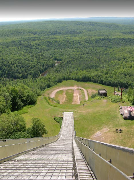
Copper Peak balances precariously atop its ridge, a skeletal monument to ambition. Constructed in 1970 to invigorate the regional economy, it now survives as a vestige of a more optimistic era, its ski-flying glory reduced to nostalgia and tourism. I rest my pack on a picnic table and carry my improvised wallet—a plastic bag containing twenty-five dollars—into the visitor center. I must ration my cash. Camping fees loom ahead, and no ATMs exist between here and Marquette.
My heavy boots pound against the wooden porch like a draft horse. Inside, the gift shop feels suspended in time—a modest wooden structure crammed with trinkets, postcards, and yellowed clippings celebrating ski-flying triumphs of the 1970s. I ask the attendant, a bearded man of about forty, the cost to reach the summit.
“Eight dollars by elevator, five by lift,” he replies.
I inquire about the lift’s history.
“Want to watch a video?” he asks, pride bright in his eyes. I agree. He inserts a VHS tape into a VCR connected to an aging Zenith television with a rotary dial.
“Confounded thing. Why won’t it cooperate?”
While he fiddles with cables, I address five postcards, affixing preprinted labels I packed for precisely this purpose.
“The cable’s missing,” he mutters, disappointed. “Is that your pack outside?”
“Yes. I’m through-hiking. I plan to pick up the North Country Trail up the road. Is the trailhead obvious?”
“North Country Trail? It’s on the right—you can’t overlook it. Where are you headed?”
“St. Ignace. I started in Ironwood yesterday.”
“You’ve got miles ahead of you. Name’s Frosty.” He extends his hand.
“Tango,” I respond, shaking it.
He grins. “Trail name?”
“Affirmative.”
Frosty recounts his hikes, his home in Wisconsin, and his work managing the ski jump with his son. He tells me he seldom encounters through-hikers.
“You’re the first this year.”
The first. I expect more traffic along the North Country Trail—perhaps five or ten hikers each summer traversing the Upper Peninsula. Maybe others bypass this stop.
He offers practical advice about the trail ahead.
“You’ll likely see bear.”
I silently hope otherwise.
After thanking him, I resume marching along the highway. By noon I lag behind schedule. About a mile later, two routed wooden signs—“North Country Trail” and “Ottawa National Forest”—signal salvation. Relief washes over me. I drop my pack and eat lunch: pita bread, tuna, cheese sticks. The meal proves sufficient but unremarkable. A two-hour nap follows.
A white cargo van jolts me awake. Nine preteen girls spill from the vehicle.
“I’ll pick you up at Presque Isle in two days, right?” a man calls from the driver’s seat.
“Yes,” replies the eldest, her braided pigtails giving her a Heidi-like appearance.
Not wishing to intrude, I shoulder my pack and slip onto the trail. At last, authentic tread—rocky, root-laced, uneven. I had not anticipated true trail until beyond the Black River Recreation Area, yet here it unfolds in rugged splendor.
The North Country Trail began as a U.S. Forest Service proposal in the mid-1960s. Congress established the National Trails System in 1968, initially recognizing only the Appalachian and Pacific Crest Trails. In 1980, legislators authorized the North Country National Scenic Trail. Though administered by the National Park Service, construction and maintenance rely heavily on volunteers and nonprofit trail clubs. As a member of the Chief Noonday Chapter, my dues support segments in Barry and Calhoun Counties.
More than 1,500 miles of the envisioned 4,000-mile corridor stand completed, over one-third in Michigan. When finished, it will claim distinction as the longest National Scenic Trail, stretching from the New York–Vermont border to Lake Sakakawea State Park. Blue diamonds guide hikers along certified stretches; today they steer me through white pine and hemlock forest along a rocky escarpment.
I blow my whistle—“TRRRRWWWWEEEETTT!”—to discourage bears. The Black River runs low. Waterfalls punctuate its descent across ancient igneous bedrock of the Canadian Shield.
Chippewa Falls barely exists, diminished to rapids by drought. I traverse sixty feet above the river like a cautious tightrope walker. A northern waterthrush flits along the water’s edge, plucking insects from purple-tinged rock.
Algonquin Falls remains elusive. Through the trees I glimpse swirling current but no dramatic plunge.
Conglomerate Falls earns its name from a massive chunk of metamorphic rock dividing the river before it drops roughly thirty feet. Tourists gather here, assisted by a parking lot, a stairway, and a trail. I pause, contemplating time and insignificance. I am a speck amid billions of years.
A boardwalk leads north to Potawatomi Falls, where water spills gently over a rock lip. The terrain near each cascade appears barren—no vegetation within twenty feet of the river. The explanation seems evident: dense rock resists colonization, and winter ice scours whatever life dares attach.
Gorge Falls occupies a V-shaped valley of conglomerate stone. In spring it must roar; today, it whispers. Sunlight refracts off wet rock, scattering glints into the dim forest.
The trail undulates relentlessly. Up, down, up again. I fixate on my aching feet. If I glance away for more than two steps, I risk stumbling. My shoulders burn beneath a forty-five-pound pack—lighter than before but still burdensome.
After two hours of intense focus, I rest briefly. The girls approach, boots clattering. I follow at a respectful distance until they pause again atop a steep rise. I climb, breath ragged.
“Hi, I’m Tom. Where are you from?”
“Waukesha, Wisconsin,” the braided girl answers.
“Are you with a trail club?”
“We’re Voyagers,” she explains. Their organization intends to hike the entire NCT across Wisconsin and Michigan, segment by segment.
“Where are you going?” she asks.
“St. Ignace—the Mackinac Bridge.”
Their eyes widen.
“How long will that take?” a younger girl in glasses inquires.
“About forty-five days.”
They pepper me with questions: food resupply, transportation, purpose.
“Why?”
“You have to live deliberately,” I answer. “I just turned thirty. This is my birthday gift to myself. I decided to attempt something audacious.”
I shoulder my pack and continue.
The trail rejoins Black River Harbor Road about a mile from the recreation area campground. I limp into the grounds—trim sites, pit toilets, potable water. Exhaustion engulfs me. I select the nearest site, collapse onto the picnic table bench, and drift into another nap.
Later, I telephone Don.
“Tom! How are you?” he asks.
“Fatigued. My feet throb. Otherwise, progress continues.”
I met Don at Western Michigan University through Dan Miller. Don has served with the National Park Service, the National Wildlife Refuge System, and the U.S. Forest Service as a hotshot firefighter. He understands hardship. I request moleskin and duct tape; he promises to notify Sylvia Miller, who manages my resupply logistics.
“When will I hear from you next?” he asks.
“Hopefully, tomorrow from Presque Isle. If not, initiate search and rescue by Friday at six.”
He has my itinerary.
I return to camp. Heat and humidity cling unexpectedly to Lake Superior’s shoreline. Clouds thicken. Then—
Drip. Drip. Drip.
Rain.
I rig my tarp hastily between the picnic table, trees, and the post. It sags too low; mosquito netting brushes my face. The insects whine inches from my ears. Wind replaces rain, gusting through the grove. I rate the bug factor a four on my personal scale of ten—tolerable but demanding defensive measures.
Sweat saturates my clothes. I wriggle into pants, long sleeves, and a mosquito jacket as temperatures dip toward seventy. The insects persist. I curse softly.
Then, as abruptly as they arrived, they vanish.
Fully armored against an enemy that has retreated, I finally surrender to sleep.